
In the morning we take Tadesse’s former colleague to Tarcha (waypoint 229, altitude 1426 m). After the weekend he has to go back to work. Tadesse is allowed to photograph hand-drawn maps in the Zonal Administration Office. There is nothing else in print depicting the new administrative boundaries.
Photographed:
|
Location |
Picture No. |
Subject |
|
Waypoint 230 |
7-8 |
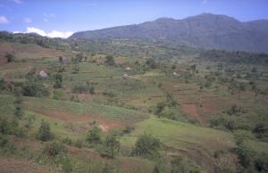
Lat. 7° 2' 18.08" N / Long. 37° 11' 58.6" E View on Arusi Mogisi, a small locality located in the district named Mareka Woreda |
|
Waypoint 231 |
9 10 |
Lat. 7° 1' 54.41" N / Long. 37° 13' 17.55" E View of the small locality of Gassa Landscape, view of the Tulama region of Dawro |
|
Waypoint 232 |
11-12 |
Lat. 7° 0' 28" N / Long. 37° 16' 9.18" E Farmsteads |
|
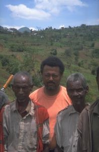
Waypoint 233 |
13-20 |
Lat. 6° 58' 32.4" N / Long. 37° 18' 30.52" E Agricultural landscapes; house; old farmers with Tadesse |
|
|
|
Move mouse over pictures to see a larger version with captions
The old farmers in the picture had been working on the field below and had been engaging in a shouting conversation with Tadesse, with occasional interjections by other farmers even further down the valley. Finally, they came up to the road. They enumerated a multitude of different Christian churches active in the area. Their old assembly places have been destroyed by church activists. There was a huge tree, the bark of which was cut all around by members of Qaale Hiwot, a Protestant church.
Photographed:
|
Location |
Picture No. |
Subject |
|
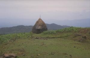
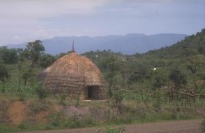
Waypoint 234 |
21-26 |
Lat. 6° 56' 20.24" N / Long. 37° 22' 23.43" E Huts; view of the slope; Tadesse interviewing people by the roadside |
Hut (picture No. 22)
Move mouse over picture for larger version
|
Location |
Picture No. |
Subject |
|
Waypoint 235 |
27 |
Lat. 6° 54' 36.59" N / Long. 37° 24' 40.71" E View of one of the walls towards the Omo valley |
|
Waypoint 236 |
28-29 |
Lat. 6° 53' 56.06" N / Long. 37° 25' 3.85" E Wall |
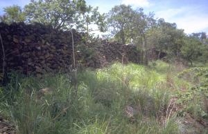
Wall, waypoint 236 (picture No. 29)
Move mouse over picture for larger version
|
Location |
Picture No. |
Subject |
|
Waypoint 237 |
(no picture) |
Lat. 6° 54' 24.08" N / Long. 37° 26' 4.17" E Bridge across the Omo, altitude 779 m |
|
Waypoint 238 |
30-32
|
Lat. 6° 54' 30.59" N / Long. 37° 26' 30.97" E Views across the Omo valley from the Wolaita side; walls. Panoramic views |
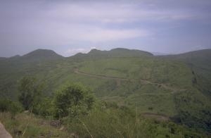
View across the Omo valley from the Wolaita side, waypoint 238 (picture No. 32)
Move mouse over picture for larger version
Tadesse, whose mother tongue is Gamo, seems to have no difficulty in conversing with Wolaita or Dawro. The Omotic languages of these three groups seem to be closely related. Tadesse thinks that the level of differentiation among the three might not be higher than that between Boran, Arsi, and Guji. And if the latter can be grouped together as Oromo in one regional state, why can’t these other three Omotic peoples be grouped together in a similar way?
In fact, the Gamo, Wolaita and Dawro all belong to the same regional state, namely the Southern Nations, Nationalities and Peoples Regional State; but that is a “mixed bag” in which they are thrown together with more distantly related and unrelated groups. And, within that state, they do not form a single unit, say, one Zone, but three different ones. If one compares the logic of classification at work here with that found in Oromia, one finds that they are inconsistent with each other.
(Last year, there was an initiative by the government to organise them as one unit [presumably with subdivisions], but people resisted this [oral communication from Getinet, Addis Ababa, May 11, 2002].)
Back to Soddo and then on to Arba Minch (see map 12).
Interethnic clan relationships: On the way along the western shore of Lake Abaya, Tadesse explains that there are small pockets of Arsi Oromo living among the Gamo. They have old-standing arrangements on the level of clan or lineage organisation: certain Arsi are affiliated with certain Gamo, and these relationships are also recognised by the respective Arsi clans on the Oromia side. These cross-cutting relationships are the type of thing Oromo nationalists do not want to hear about.
Burji/Koira/Konso/Oromo should also be examined for such interethnic clan links. Likewise for the Kaffa/Oromo/Dawro.
Tadesse’s informant from the qawot clan in Dawro, which is believed to originate from Gondar, interviewed in Tarcha (see entry from April 21, 2002), told us that he would rather have his ears cut off than understand Oromo; but enmity does not preclude interethnic clan relationships.
Baiso: Tadesse also thinks that the Baiso on the islands of Lake Abaya, who Fleming (1964) classifies linguistically as 'Somali outliers' similar to the Rendille, deserve to be studied. They are or were important for the trade across the lake.
Resettlers, the State: The exclusive association of large-scale resettlement with the Derg period is wrong. Along the western shore of Lake Abaya there are settlements of people from Gondar that date from the period of Haile Selassie. Also, many Falasha were resettled here at that time. Later they were taken to Israel. The present government continues with resettlement on a "voluntary" basis, despite of the inconsistency of this policy with other policies based on ethnic territoriality.
The creation of large state farms and the planting of a huge eucalyptus forest, owned by the central government and located on former communal pastures, required resettlement of the former users, who have, however, not received any compensation.
Ethnic conflicts
Guji / Gedeo: In 2001 (?), Guji massacred Gedeo who lived interspersed among them. Three thousand of them were killed, and many were expelled. The Gedeo did not retaliate in a similar fashion against Guji living among them because of the many links to them through marriage. The incident was reported on VOA (Voice of America). Taddesse Berisso also mentioned it in the paper he presented in Halle/Saale (2002). Other "Oromo warriors" are said to have helped their Guji brothers, but it is hard to imagine this without some form of central command and lorries for logistics. Sources: EHRCO, Ethiopian Human Rights Committee Report, check on internet: http://www.ethiopiafirst.com.
Majangir: Majangir went to the government offices in Tepi town to kill officials with spears. According to some newspapers, four policemen were killed. It is also reported that the Majangir came from four directions, each group comprising one man with a kalashnikov and ten with spears. Their attack caused complete chaos. Since then, many people have abandoned the town (oral sources in Dawro; see also contribution by Ren’ya Sato in Remapping Ethiopia [2002] about Majangir). Tadesse thinks this particular conflict is about Majangir land that was appropriated for the town and for coffee plantations in the hands of Wollo settlers.
Manja / non-Manja among the Kaffa: The Manja are the hunter-gatherers living among the Kaffa and Dawro. They live in enforced endogamy. There is no commensality. They experience discrimination of every variety.
The Manja are in control of the forest. Armed groups have started to kill Kaffa. The army was sent against them. Manja captives said they would kill more. People think this uprising is connected to the activities of the Pan-Ethiopian movement in Gambella, led locally by a Nuer.